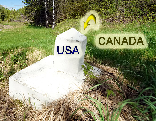
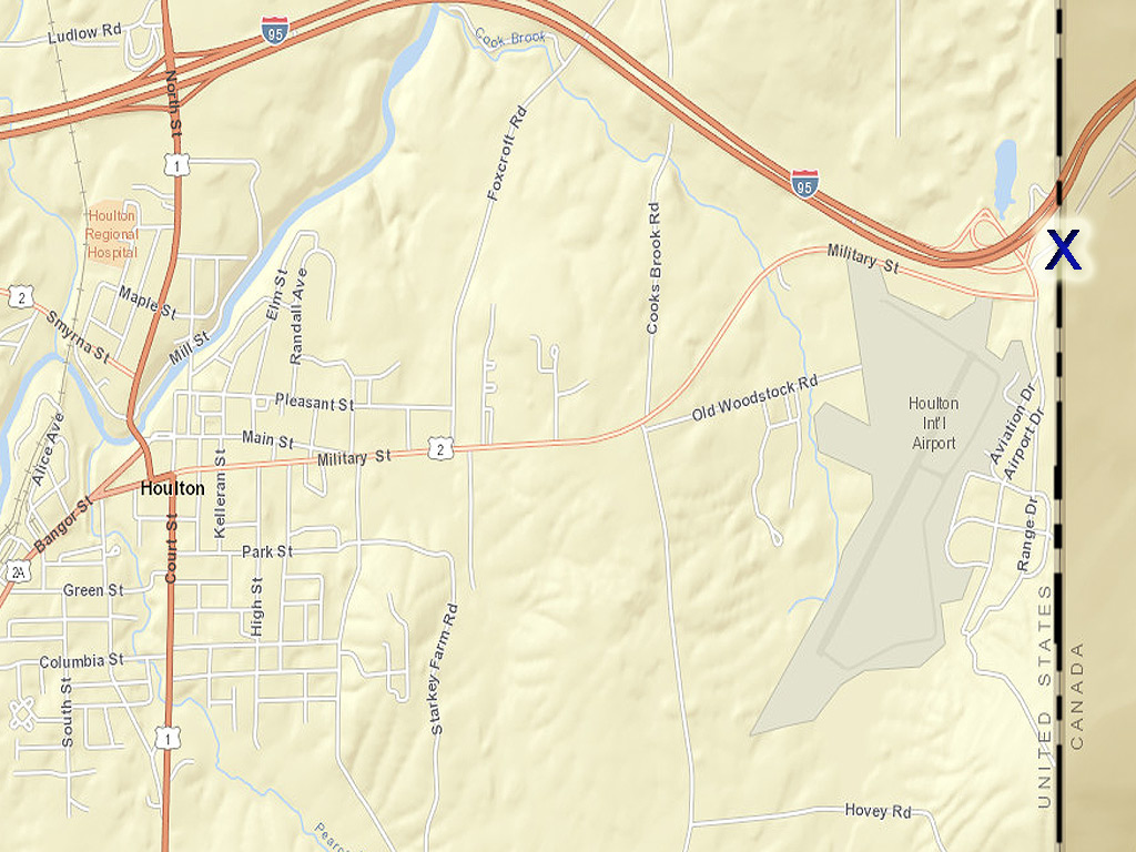
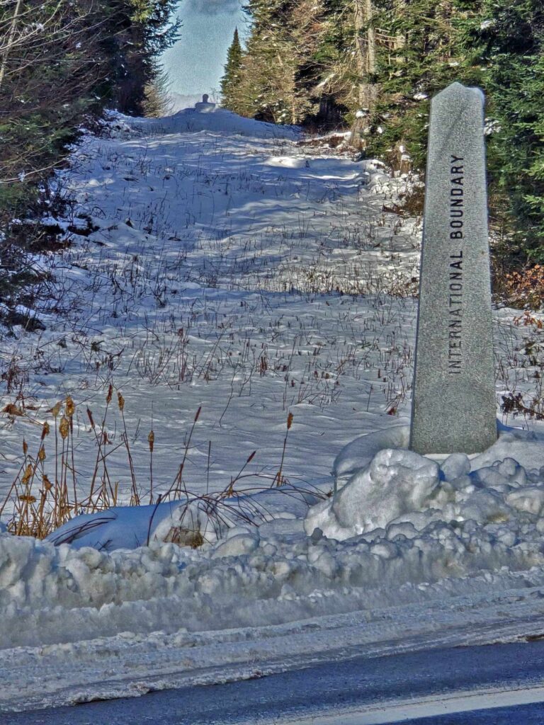
International boundary between Maine and Canada.
Let’s face it, Maine is pretty much sticking up all by itself in the right hand corner of the US. Quebec and New Brunswick Canada surround Maine wherever the rugged rocky coastline does not right?
So for someone growing up in a Maine border town like I did in Houlton Maine, Aroostook County, it’s no big deal. But in my job as a Maine real estate broker, I get asked a lot what it is like being on the Maine-US-Canadian border.
There are a lot of perks being a Maine border town with Canada.
We are all related too back and forth on both sides of the International boundary between Maine and Canada. If you kids play hockey, you definitely get to know your way around the Canadian provinces and where all the ice arenas are located.
Canada is a lower cost easy to access vacation option too for close to home get away with the stronger US dollar.
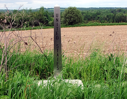
But the International boundary line border crossing and markings to divide the two countries Maine and Canada.
How does that work so the average Joe and Jane know which is which to avoid wandering over from one to the other by mistake?
Where I live, there are lots of roads that used to be border crossings that are not blocked off and dead end.
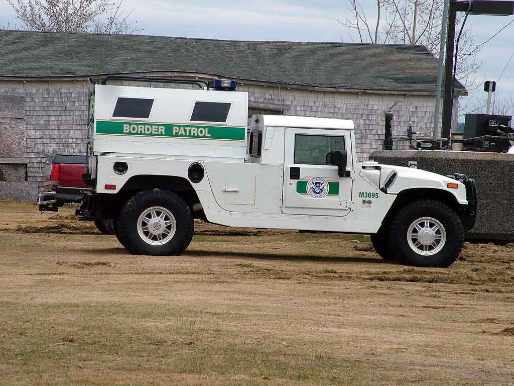
Whenever I am listing or showing properties in Maine near the border. It is not uncommon to see the white pickup. The one with the green line down across it.
US Border Patrol’s sector headquarters is in Houlton Maine.
Since 911 happened, a bigger beefed up presence is felt on both sides of the International boundary line border crossing.
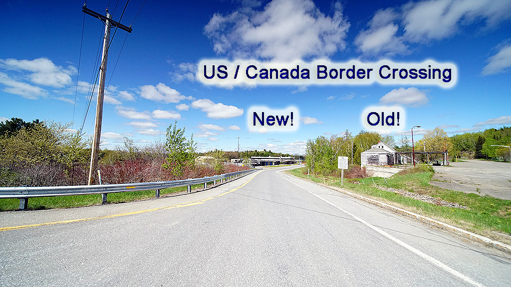
This is what you see crossing from New Brunswick Canada into Houlton Maine’s US port of entry for a boundary market.
The International Boundary Commission (IBC) is responsible for surveying and mapping the Canada–United States border.
This includes the boundary between Maine and Canada.
The IBC maintains over 8,000 monuments and reference points along the 8,891 km (5,525 miles) boundary.
This kind of attention to keeping the boundary line crystal clear on foot or visible from the air ensures its clear demarcation.
No misunderstandings where things starts or stops.
Spacing of Boundary Markers:
- Primary Monuments: These are placed at significant points along the boundary, such as where the line changes direction or at major geographical features.
- The spacing between primary monuments varies depending on the terrain and visibility requirements.
- Intermediate Markers: In areas where additional visibility is needed, smaller intermediate markers are installed. To use between primary monuments to ensure the boundary line is clearly defined.
Maintenance of the Boundary:
- Cleared “Vista”: The IBC maintains a 6-meter (20-foot) wide cleared swath, known as a “vista,” along the land boundary line. This clearing extends 3 meters (10 feet) on either side of the boundary to keep the line visible and prevent overgrowth.
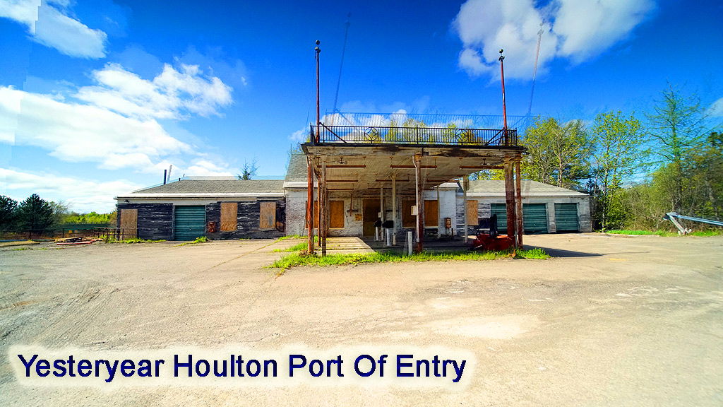
Houlton Maine Old Abandoned US Port Of Entry Customs Immigration Station.
Accessing Boundary Maps and Coordinates:
- Official Maps: The IBC provides access to official maps and the most recent geodetic coordinates of the international boundary.
- These resources are organized into sections and subsections corresponding to areas with homogeneous characteristics.
- Digital Boundary Data: For mapping purposes, the IBC offers digital boundary data generated from NAD83 geographic positions of boundary monuments and turning points.
- This data is intended for mapping use only and should not be used to define the legal boundary.
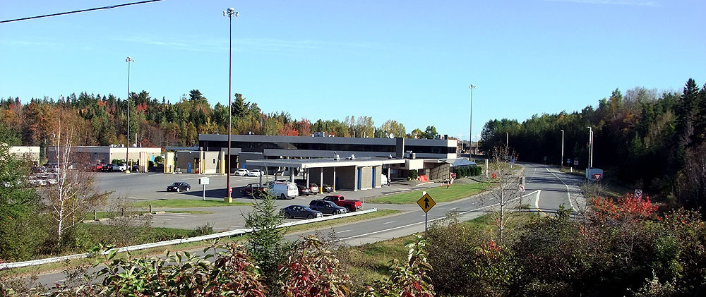
Crossing From Maine Into Canada, The Houlton Port Of Entry Station.
Want more detailed information on specific marker locations, spacing?
And to view official boundary maps, you can visit the IBC’s Maps & Coordinates page.
This resource provides comprehensive maps and data pertinent to the Maine-Canada boundary.
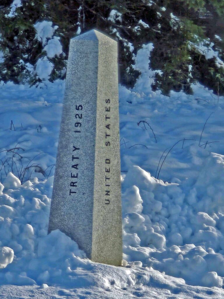
Coming back from a one day over and the next back from Maine to Fredericton New Brunswick. There was a short line at the port of entry.
Took a few photos of the granite markers you see out the car window making it crystal clear which country you are entering or leaving.
What about the International border market spacing?
The distance apart of boundary markers along the Maine-Canada border varies.
It’s all visual, line of site.
It all depends on the terrain, visibility, and historical agreements.
But the boundary line markers are generally placed at intervals of 1 mile or less. Here’s a detailed breakdown:
1. General Spacing Guidelines
- Primary Boundary Monuments: These are typically placed at significant points, such as river crossings, ridge lines, or areas where the boundary changes direction.
- In flat or open areas, primary markers may be spaced 1 mile apart.
- In more rugged or forested areas, the spacing might be shorter to ensure clear delineation.
- Intermediate Markers: Smaller markers are placed between primary monuments in areas where additional visibility is needed.
- This helps reduce the distance between markers to several hundred yards.
2. The Cleared “Vista”
- A 20-foot-wide cleared strip along the boundary (called the “vista”) ensures the border remains visible. Even when the markers themselves are spaced farther apart.
- The vista allows surveyors and travelers to visually follow the border line.
3. Variations in Marker Placement
- In areas with natural boundaries (e.g., the St. John River), markers are placed at key access points rather than at regular intervals.
- In heavily forested or less accessible regions, markers may be closer together to aid navigation and ensure clarity.
4. Surveying Standards
- The International Boundary Commission (IBC) is responsible for maintaining and inspecting the markers. They ensure markers are appropriately spaced and replace damaged or missing markers as needed.
- Modern GPS technology and historical records are used to ensure the accuracy of the boundary line and marker placements.
5. Practical Implications
- For those traveling along the border or inspecting it. Those markers and the cleared vista provide a clear and continuous visual reference for the international boundary.
- The system ensures that the boundary is well-defined despite challenging geography or changing environmental conditions.
If you’re looking for precise distances or a specific area of interest, the International Boundary Commission’s maps and reports provide detailed information about marker locations and spacing.
The Maine-Canada border took a long time to resolve due to a combination of geographical, political, and economic factors. Here’s why it was so complex and why the issue persisted for decades:
Why did it take so long for the boundary line to be determined and agreed upon by both countries?
1. Ambiguous Language in the Treaty of Paris (1783)
- The Treaty of Paris, which ended the American Revolutionary War, was supposed to define the boundaries between the United States and British-controlled Canada. However, the language describing the northeastern boundary was vague. It relied on natural landmarks like rivers and highlands. Those were poorly mapped at the time.
- The treaty referred to the “highlands which divide rivers flowing into the St. Lawrence from those which flow into the Atlantic.” This definition was open to interpretation. It caused disputes over which “highlands” were being referenced.
2. Poor Mapping and Limited Knowledge of the Region
- Maps of the late 18th and early 19th centuries were often inaccurate. Surveying techniques were rudimentary. The dense forests of northern Maine and New Brunswick made the region difficult to explore.
- Early maps, like the Mitchell Map, which was used during the Treaty of Paris negotiations, were misleading and contributed to the confusion.
3. Competing Economic Interests
- The Aroostook River Valley was rich in timber, and both the U.S. and Britain (Canada) wanted control of the resources. The economic importance of the logging industry intensified the territorial dispute.
- Settlers from both sides began using the disputed land, increasing tensions as they competed for resources.
4. Strategic Importance
- The British sought a secure land route between their maritime colonies (New Brunswick, Nova Scotia) and Quebec. Control of the disputed territory was critical for maintaining this connection.
- The U.S., meanwhile, wanted to expand its territory. To secure the US Canada border for future settlement and economic development.
5. Settlement Patterns
- By the early 19th century, settlers from both sides were already living in the disputed territory. These communities, especially French-speaking Acadians, complicated the issue. They often had loyalties that crossed national boundary border lines.
6. Political Tensions Between the U.S. and Britain
- The War of 1812 heightened tensions between the U.S. and Britain, delaying a peaceful resolution to the border issue.
- After the war, negotiations resumed but were slow. Each side feared conceding territory, which might be seen as a sign of weakness.
7. The Aroostook War (1838-1839)
- The boundary dispute escalated into the Aroostook War, a bloodless confrontation involving American and British/Canadian militias. This underscored the urgent need to settle the boundary dispute.
- Both sides recognized that armed conflict over the issue was undesirable, leading to intensified negotiations.
8. Resolution: The Webster-Ashburton Treaty (1842)
- The boundary was finally settled through diplomacy with the Webster-Ashburton Treaty. Negotiated by U.S. Secretary of State Daniel Webster and British diplomat Lord Ashburton.
- The treaty divided the disputed territory. Giving most of the Aroostook Valley to the U.S. while ensuring Britain maintained access to critical transportation routes.
9. Post-Treaty Adjustments
- Even after 1842, there were minor adjustments and surveys to finalize the border. This slow process reflected the ongoing need to map and mark the boundary accurately.
Conclusion
The Maine-Canada border dispute took so long to resolve because of vague treaties.
Poor maps, economic competition, and geopolitical tensions did not help the geography lesson.
The railroads on both side of the border pushed hard to know where the dotted line was going to be.
Before laying iron rails nailed to railroad timbers and clearing lines, building bridges. Not so easy when governments with history good and bad between them causes some hard feelings.
Defining borders in uncharted and contested territories is challenging. Ultimately, diplomacy prevailed, setting a precedent for peaceful resolution of disputes between the U.S. and Canada.
I’d always heard the final boundary line was decided with a bottle of whiskey.
Maybe they cut the cards or were playing horseshoes. That’s a blog post for another day.
The history of the U.S.-Canada border in Aroostook County, Maine, is deeply intertwined with the early settlement of the region, diplomatic disputes, and economic development.
Aroostook County, located in northern Maine, shares a lengthy border with the Canadian provinces of New Brunswick and Quebec. Here’s an overview of its border history:
Early Settlement and Indigenous History
- Before European settlement, the region was inhabited by the Wabanaki Confederacy, particularly the Mi’kmaq and Maliseet tribes, who lived on both sides of what is now the border.
- They traveled and traded freely along the St. John River and its tributaries.
- French explorers and settlers established a presence in the region as part of Acadia in the early 1600s, laying the foundation for French influence in the area.
British and American Claims
- The Treaty of Paris (1783), which ended the American Revolutionary War, was vague about the precise location of the northeastern boundary between the newly formed United States and British-controlled Canada.
- This made it kinda fuzzy. Leading to ambiguity and disputes over the border in what became Aroostook County.
- Settlers from both sides began populating the region, especially along the St. John River. The mix of French Acadian, British Loyalist, and American settlers complicated territorial claims.
The Aroostook War (1838-1839)
- The boundary dispute came to a head during the so-called Aroostook War, a bloodless confrontation between American and British/Canadian lumberjacks and militia forces.
- Both sides wanted access to the rich timber resources of the Aroostook River Valley. The conflict escalated as Maine and New Brunswick sent forces to assert their claims.
- The dispute was resolved diplomatically through the Webster-Ashburton Treaty of 1842, which established the current border. The treaty awarded most of the disputed land to the U.S. but ensured British access to the St. John River for navigation.
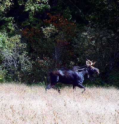
No Passport Needed. Maine And Canadian Moose Travel Back And Forth Across The International Border. 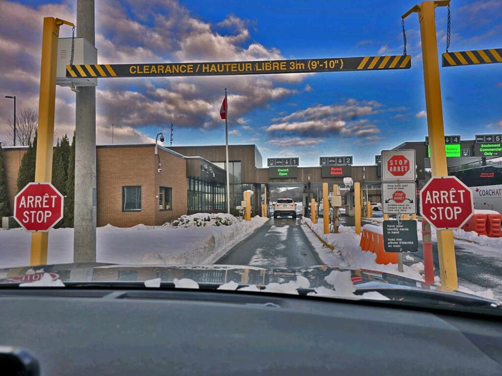
Inspection, The Stop To Roll Down The Window, Hand Over The Passport.
Economic and Social Ties
- Despite the formal border, economic and social connections remained strong between Aroostook County and neighboring New Brunswick. The logging industry and later the potato industry fostered cross-border trade and relationships.
- Families often had members on both sides of the border, and shared cultural ties endured, especially among French-speaking Acadian communities.
Modern Era
- Today, the U.S.-Canada border in Aroostook County is marked by official crossings like those in Fort Kent, Van Buren, and Houlton. These towns remain gateways for trade and travel between Maine and Canada.
- While stricter border controls were implemented after the September 11, 2001, attacks, the region continues to rely on its cross-border relationship for economic and cultural exchange.
Significance
- The history of the Aroostook border reflects broader themes in U.S.-Canadian relations, including the peaceful resolution of disputes, the blending of cultures, and shared economic interests.
- The resolution of the Aroostook War and the establishment of a clear border underscored the importance of diplomacy. It set a precedent for U.S.-Canada cooperation.
This region’s unique history remains a point of pride for residents on both sides of the border.
We are all related back and forth.
It all helps emphasize the shared heritage and interdependence despite the international boundary.
In my job as a Maine real estate broker, the question comes up a lot.
More than you would probably think.
Is it dangerous being this close to Canada living in Maine?
No. Heck no.
It is a perk being on the Canadian border as a Maine small boundary line town.
Both sides enjoy traveling back and forth and the cross border traffic is constant.
It was hard when COVID shut down the crossing ease for both sides and makes us glad we can travel freely now.
We have blogged about traveling to PEI Canada vacations before.
And trips from Maine to Halifax Nova Scotia.
These quick and easy, affordable vacations close to home are a one more benefit of living in Maine.
We take more of these trips to explore different times of the year and to expand where we stay and find new things to enjoy. Quebec is full of history and fun to travel to from Maine.
Thank you for following our Me In Maine blog loyal and faithful readers.
And if you are new to this blog about anything Maine, welcome.
Please reach out online or stop in to see us if in Northern Maine.
I love where I live and want to share all I know about Maine with you.
Please visit the blog post of Maine search bar in whatever interests you. Let me know anything for future Maine blog post topics to cover.
The images are all personally collected and you may even find a video or two from the YouTube Maine community playlist. Please share these blog posts around your social media circles.
I’m Maine REALTOR Andrew Mooers, ME Broker
207.532.6573 | info@mooersrealty.com |
MOOERS REALTY 69 North ST Houlton ME 04730 USA